The following Good Practices on the beneficial use of Earth Observation and satellite data in cultural heritage protection were kindly provided as case studies by their managers or researchers. The SATCULT team would like to express its gratitude for the trust they have placed in us. Here is the overview (in alphabetical order of the managers/researchers) with links to all Good Practices:
| Title | Location | Topic | Institution | Names of the contributors |
| GIS-based Attribute Mapping of UNESCO World Heritage Sites: A Case Study of the Baden-Württemberg Section of the „Prehistoric Pile Dwellings around the Alps“ | Lake Constance, Upper Swabian wetlands, Germany | Underwater Archaeology Monitoring | Heidelberg University of Education | Paul Bobsin |
| INnovative strategies for the Adoption of risk management plans to enhance the resilience of sensitive Cultural and natural heritage Objectives against climate hazards in river basin districts – INACO Interreg CE Project | European and Mediterranean Basin | Climate Change impact on Cultural and Natural Heritage, support for policy makers and decision makers | Consiglio Nazionale delle Ricerche – Istituto di Scienze del Patrimonio Culturale | Alessandra Bonazza |
| Heritage Monitoring in Post-Earthquake Türkiye: Integrating Citizen Science with Cutting-Edge Remote Sensing | 12 earthquake-stricken provinces in Turkey | Handling the monitoring of damages after an earthquake with inclusion of citizen science and volunteers | Ege and Akdeniz Universities (Türkiye) | Çiler Çilingiroğlu |
| Pattern Extraction Methods and LiDAR Technology for Analyzing and Mapping Archaeological Looting | San Giovenale, near Rome, Italy | Archaeology, Looting | Consiglio Nazionale delle Ricerche – Istituto di Scienze del Patrimonio Culturale | Maria Danese |
| Using Satellite Imagery and Geospatial Information Technologies (GIT) to Support Cultural Property Protection (CPP) in Ukraine | Ukraine, Lviv | Training for cultural heritage professionals in coping with war destruction | UNOSAT in partnership with UNESCO | Michelle de Gruchy |
| Monitoring of Meadow Orchards | Neckarsulm, Germany | Protection of cultural landscape | Heidelberg University of Education – Research Group for Earth Observation | Paul Joseph |
| Space to Tree: Earth Observation based monitoring of natural and historical Park | Rome, Italy | Monitoring of a heritage site | Consiglio Nazionale delle Ricerche – Istituto di Scienze del Patrimonio Culturale | Nicola Masini |
| Open-Access Remote Sensing Datasets for Monitoring Threats | Spain, Baltanás, Province of Palencia, Autonomous Community of Castile and León | Protection of heritage landscapes, especially in rural or unmonitored areas | Cyprus University of Technology | Kyriakos Michaelides |
| Hazard Exposure Map for Cultural Heritage of Museums and Monuments of Portugal | Portugal | Give museums an indication of their risk situation regarding hazards, Monitoring of geo-hazards | MUSEUS E MONUMENTOS DE PORTUGAL, E.P.E | Esmeralda Pauperio |
| Kerkennah Island Project | Tunesia | Climate change, Mitigation of impact on cultural heritage | Institut National du Patrimoine/CNRS | Katia Schörle |
| TRIQUETRA – Toolbox for Assessing and Mitigating Climate Change Risks and Natural Hazards Threatening Cultural Heritage | Poland, Poznań | Climate change, Impact on archaeology | Adam Mickiewicz University | Włodzimierz Rączkowski |
| The Choirokoitia Case Study | Cyprus | Archaeology, Monitoring of geo-hazards | Cyprus University of Technology | Kyriacos Themistocleous |
| Preserving Cultural Heritage of Aquileia and its territory | Italy, Aquileia | Archaeology, Land use planning | Istituto Italiano di Tecnologia | Arianna Traviglia, Giulio Poggi |
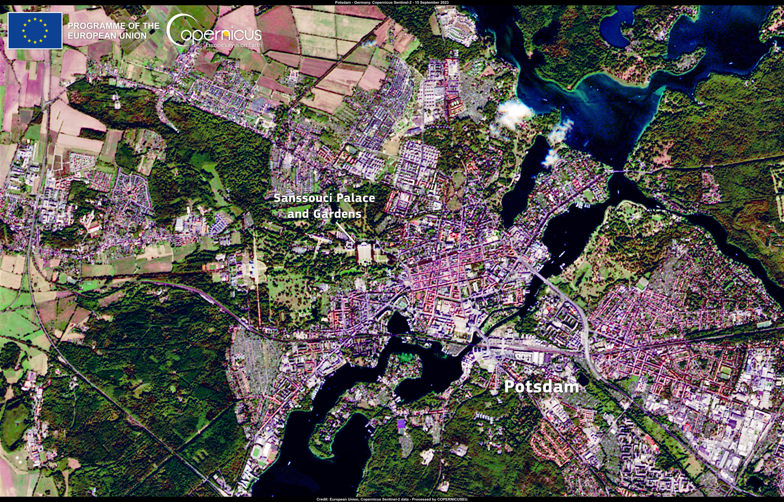
Picture credit of the title picture: Copernicus https://www.copernicus.eu/en/media/image-day-gallery/climate-change-puts-world-heritage-sites-risk
(„Climate change poses a threat to World Heritage Sites, endangering their integrity and unique beauty.
This image, acquired on 15 September 2023 by one of the Copernicus Sentinel-2 satellites, shows the Sanssouci Palace and Gardens in Potsdam, a 300-year-old World Heritage site in Germany.
During the past years, this historic jewel has been hit by heatwaves, droughts and heavy rains, resulting in the death of trees, the impoverishment of the soil, and the drying of the groundwater, putting the landscape under threat.“ Citation from the Copernicus website.)